#95 - Monsoons & Mountain Trails

The trail to Silver Peak is four and a half miles. With its trailhead just up the road from my campsite, and beginning with an ascent of a ridge just behind my corral, the Silver Peak Trail #280 has an elevation gain of three thousand feet. It is a true test of endurance. Many locals hike the "first mile to the first gate" as exercise. Despite the thousands of feet of vertical ascent ahead, this switchback-free stretch is one of the toughest along the trail, states the trail description.

Even though I can shortcut the trailhead and climb the hill behind the corral to access the trail, I waited until this morning to visit it for the first time of the year. I did not heed the forecast. Two days ago monsoon season officially kicked off with localized thunderstorms that brought close to an inch of rain to Portal, Arizona just outside the mountains, but curiously barely registered on the Southwestern Research Station (SWRS) weather monitor three miles up canyon from me.

The North American monsoon generally affects the area from the second week of July until as late as mid-September. It is also known by locally biased names like "Arizona Monsoon, New Mexico Monsoon, and Southwest Monsoon", but North American is most appropriate as the pronounced increase in thunderstorms and rainfall is seen over much of the southwestern United States and northwestern Mexico and is geographically centered over Mexico's Sierra Madre Occidental range. Wind patterns reverse in summer as the land that has been intensely heated by the sun (thermal low pressure) causes the prevailing winds to start to flow (high pressure) from moist oceanic areas to the arid landscape. Monsoon season begins as early as late May in Mexico and arrives in Arizona and New Mexico as summer begins and June gives way to July. As temperature cools in September and drier conditions prevail, the monsoons lose their energy.

This year has been particularly dry in southeastern Arizona. Locals tell me how there was "no winter". Snow and rain were scarce. The SWRS reported one day with 0.13" precipitation in January. One significant day of rain in February brought that monthly total to just under two inches. March had one day of rainfall (0.47"), and April and May were completely dry. When a fluke rainstorm fell for two days in mid-June it was a gift from the skies, but it was due to a tropical storm off the Gulf of Mexico and didn't herald the beginning of our rainy season. But when less than a quarter inch fell on June 29 at SWRS, but closer to an inch was seen in Portal, residents rejoiced. The monsoons wouldn't truly begin for another ten days or so, but the ocotillo greened and then bloomed, the grass at the VIC grew a bit greener and baby lizards emerged.

The Fingers can be partially seen at right

The Fingers can be partially seen at right

As I passed the first 'pedestrian gate' on Silver Peak Trail this morning, I was posting scenic snapshots and videos to my Instagram story. I then looked up at The Fingers, a rocky hand reaching to the sky from the peaks, and saw the storm that was about to envelop me. I posted both my apprehension to continue on and that caution wasn't my style, and then had only moments to find a large boulder formation to protect my camera in before I was soaked and scurrying down trail to find any tree that would offer cover. Torrential rain fell and thunder boomed as lightning cracked. It would be more than an hour before I crawled out from under that pinyon pine and I was saturated. I looked back up at The Fingers and saw a waterfall had formed on an adjacent steep cliff. I had been upset with myself for not carrying my large camera bag, which as a rainfly, or at least not having a trash bag in my small knapsack to protect my camera and lens. I retrieved the lens from beneath the boulder overhang and started down the trail, but the rain started again. Once again, I huddled beneath the mediocre cover of a scraggly desert pine and this time tried to make room in my pack for the camera. It wasn't until I got back to camp that I realized that I am a bonehead and my Lowe camera knapsack actually does have a rainfly. Not that it would have mattered. When the storm's darkness came over the mountain and down the trail I had no choice but to become drenched squatting anywhere I could.


But let's go back almost two weeks to the last day of June and a different, and much drier, mountain trail. It was a day I will always remember. The Trans-mountain Road, or Forest Road 42, climbs Cave Creek Canyon up the mountain to Onion Saddle, where you can crest the northern Chiricahuas and descend Pinery (Pine) Canyon to Chiricahua National Monument or choose to drive south toward Rustler and Barfoot Parks. Onion Saddle is about a dozen miles up the mountain from Cave Creek Canyon, much of it on winding, primitive road with numerous single-lane switchbacks. The pavement ends just three miles up canyon from the Visitor Center, passes SWRS three-quarters of a mile later, and then the primitive road ascends from 5400 feet to 7600 feet at Onion Saddle. There you either drop down the mountain towards the Monument and paved roads north to Willcox, or continue to climb to Rustler Park (8500 ft) and Barfoot Park (8200 ft), where a network of trails centered around the Crest Trail (#270) runs along the peaks (hence, "crest") to the apogee at Chiricahua Peak (9700 ft). During the Horseshoe 2 Fire of 2011, much of this montane area burned and the landscape and associated trails continue to recover. Volunteer trail crews hike with chainsaws to part trees that continue to fall over the many paths that explore this alpine region.

With the monsoons yet to arrive, June is the hottest month of the year. The temperature can be as much as fifteen degrees (Fahrenheit) cooler at Barfoot and Rustler than down in Cave Creek Canyon, which itself is often as much as ten degrees cooler than the desert just outside the mountains. Barfoot and Rustler Parks are set in mixed conifer forest and the landscape is more Rocky Mountains than Sonoran or Chihuahuan Desert. Adding to the allure, they are home to montane wildlife like Steller's Jays, Mexican Chickadees, Cliff Chipmunks and, for me sexiest of all, the small, mountain rattlesnake - the Twin-spotted. Although the Trans-mountain Road is steep and rugged, with amazing vistas mixed with scary, sheer drop-offs along its single vehicle width, I ascend it as often as I can to reach cooler climes and gorgeous surroundings.

Yellow-eyed_Junco.jpg

My long-time readers will remember stories about this diminutive rattlesnake from last year's blog entry on searching the expansive high elevation talus slopes that form its habitat. Those with keen memories will also recall that I had quite the tumble on the sharp rock causing blood loss to my legs and body fracture to my ring flash. This year I have confined my exploration to the base of the rock slides and adjacent wooded areas and meadows. But discussing trails with both visitors and locals had me intrigued to explore the high altitude trails of the region.

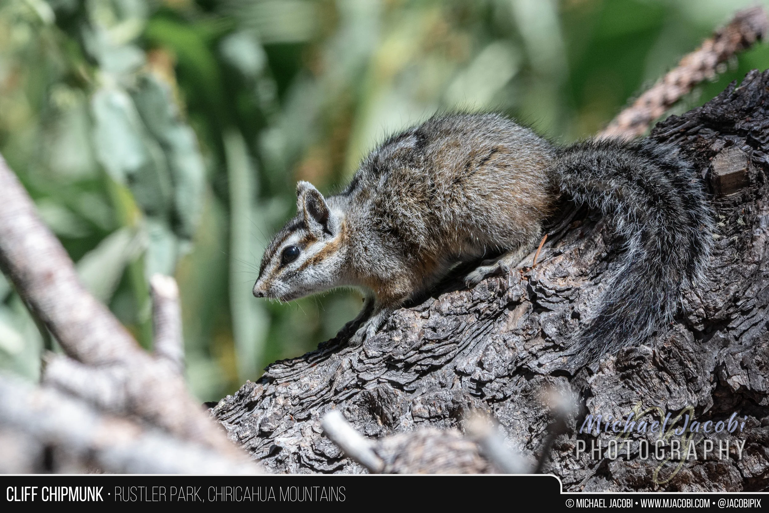
I had tried to access Barfoot a couple of days earlier, but as I drove from Barfoot Junction where you head left toward Rustler or right for Barfoot I crossed the cattle guard and was stopped by several real-life cowboys ranging cattle. It was a curious sight above 8000 ft. and I couldn't recall seeing any cattle this high before. But, there I sat, perplexed, watching a half dozen dogs circling four head of cattle lined up on the road with three or more people in Stetsons, boots and demin on horseback directing the dance. After I sat there some time, one horseman came my way and I soon realized that it was a boy no more than 14. I swear he even had tobacco in his mouth when he tipped his hat to me. Pulling his horse up beside my truck, he told me that it would be awhile. He said if he let the cattle break free they might not be able to round them up again. No worries, I told him, and I backed down the road and eventually moved on to Rustler to photograph the elusive and nervous Cliff Chipmunk.

Cliff_Chipmunk.jpg

But the trail that continued to interest me was Barfoot Lookout Trail. Although I knew that the fire lookout cabin that was built in 1935 by the Civilian Conservation Corps no longer exists, after being burned during the 2011 Horseshoe 2 Fire, the summit of Buena Vista Peak (8800 ft) now has a little stone-walled viewing area and offers a breathtaking panorama of the surrounding mountains overlooking prime rattlesnake habitat. There also is a solar panel station and radio repeater and the foundation of the old cabin and outhouse may be seen.

IMG_1722.JPG

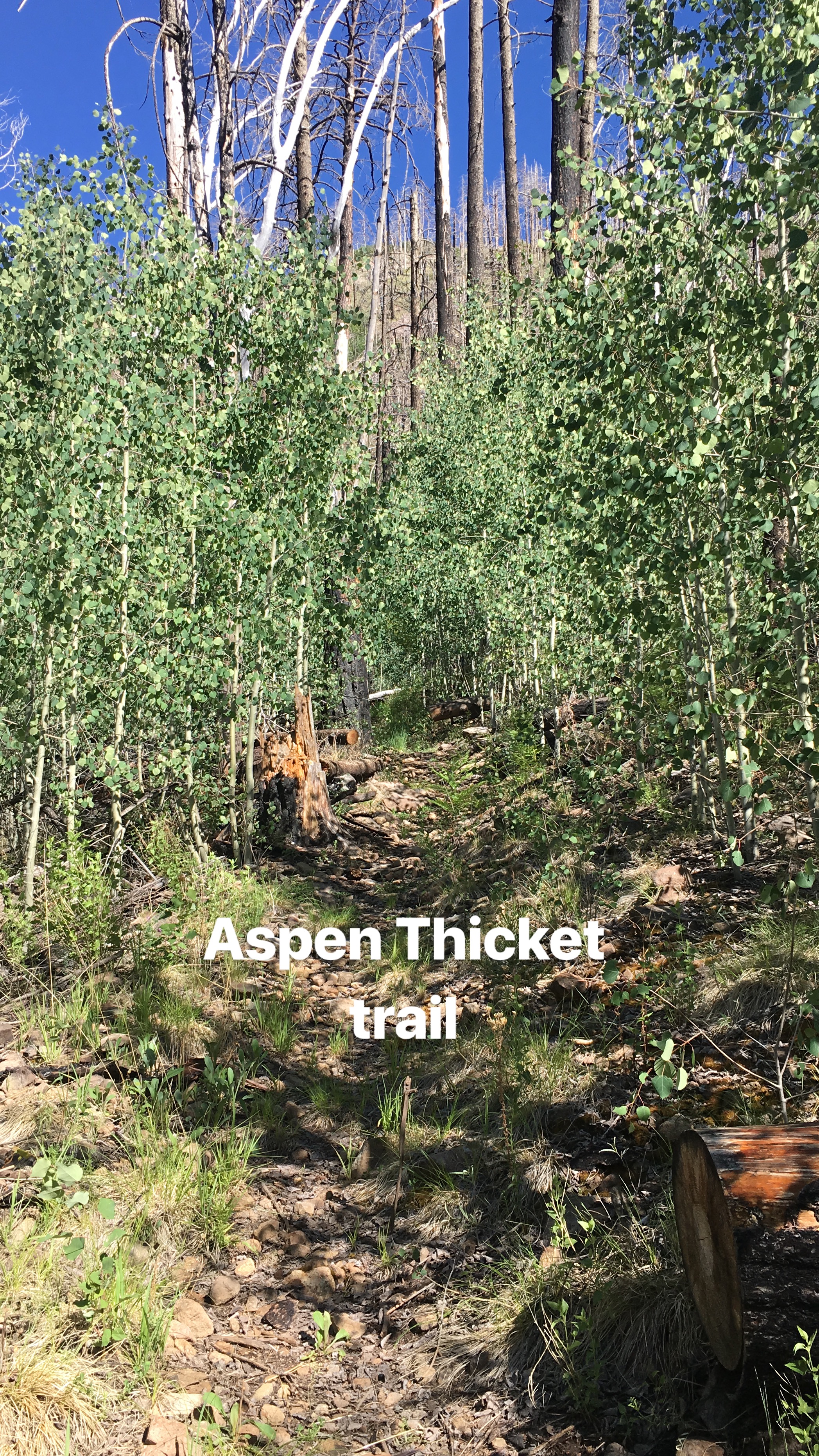
Although the Crest Trail itself intersects the Barfoot Lookout Trail, I would be starting at the lower terminus near Barfoot Meadow. It begins to climb adjacent to Barfoot Spring and after passing through a stand of burned timber reaches a thicket of quaking aspen saplings. Eventually the trail bends sharply to the left and the last three or four hundred yards climbs the mountainside without any switchbacks. Once you reach Barfoot Saddle you are at the Crest Trail junction where I chose to make the climb to Buena Vista Peak.

Along the way I would see more Yellow-eyed Juncos, a bird that thrives at the mountain tops, baby Yarrow's Mountain Spiny Lizards and, during my initial descent, Broad-tailed Hummingbirds feeding at the Bearlip Penstemon flowers abundant on the mountain slope.

The road up to Barfoot (FR 357) looking down east from the "lookout"

The road up to Barfoot (FR 357) looking down east from the "lookout"

Looking west down on whence I came ...

Looking west down on whence I came ...

IMG_1091.JPG

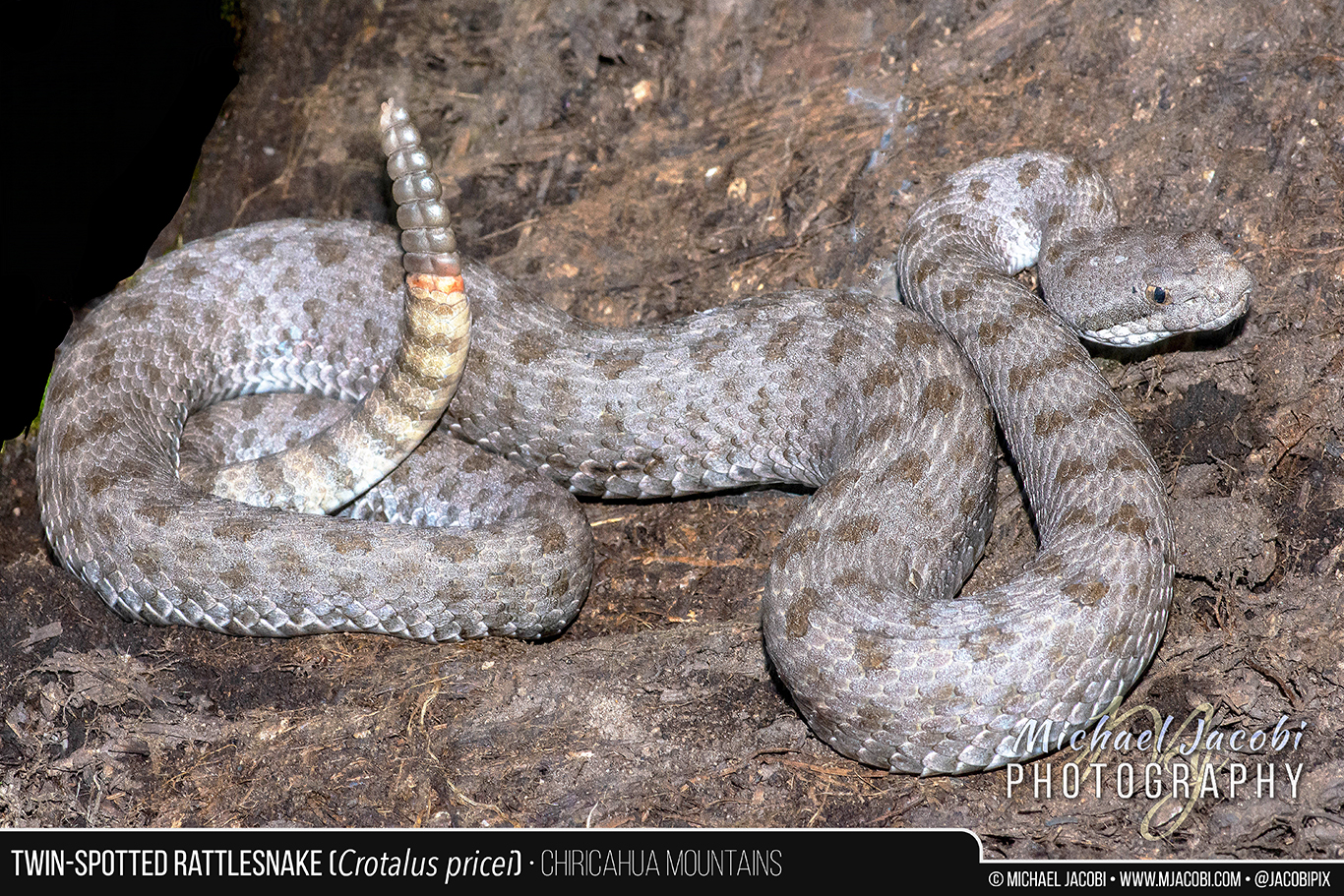
Just enjoying the trail, reaching the summit, and meditating on the spectacular vistas would have made for a wonderful Saturday. But the best was still to come. At some undisclosed point during my descent, I would stumble upon what I consider the jewel of the mountains - The Twin-spotted Rattlesnake. This protected species is a denizen of talus slopes and rock slides, but is known to be found away from much rock in the vicinity of rotting wood and other forest cover beneath the conifers. A streak of silver flashed upon the trail. I leaped forward, almost stumbling over a log or two. I am sure comedy ensued, but not even a bear was present to witness my grace. Disappearing beneath a rock on the other side of the trail, the cooperative snake gave me time to toss off backpack, camera, binoculars, hat and probably even my glasses as I tried to switch from long bird lens to macro setup in seconds. I didn't have an external flash so the lowly built-in speedlight would have to suffice. I think I may have had enough time to chug some water and wipe my brow before I kneeled beside the rock and tried to catch my breath. I had had only a momentary glimpse, but there was no mistaking that this must be a Twin-spotted Rattlesnake. The species only rarely reaches two feet in length, and this snake was every bit of it, maybe more. Nothing else was silver-grey and little else lives at 8500 feet elevation. As a protected species, it is unlawful to pursue, harass, etc. and certainly restrain or collect, so I wanted to disturb as little as possible as technically even flipping the rock would be pursuing. But flip I did, and beneath was an adult Twin-spot as big as they come and suprisingly cooperative. I wished I could pose it on rock for a better photographic setting, but I snapped a few images and then videotaped it with my iPhone as it slithered into the forest.

Crotalus_pricei_graphic_1366px.jpg
The Twin-spotted Rattlesnake (Crotalus pricei) is the smallest American rattlesnake and occurs at the highest altitude. It is a protected species found in the United States only in Arizona’s Chiricahua, Huachuca, Santa Rita and Pinaleno Mountains. Our western subspecies ranges south into Mexico (Sierra Madre Occidental) with an isolated subspecies being found in northeastern Mexico (Sierra Madre Oriental). Diminutive and slender, it is a silver, blue-grey or greyish-brown rattlesnake that only rarely reaches two feet in length. Its head is not as broad as that of most rattlesnakes, and with paired dorsal blotches that give it its name, limited range, specific habitat, and orange color of the newest rattle segments, it cannot be confused with any other snake. The Twin-spotted Rattlesnake is primarily known from Petran Montane Conifer Forest at elevations of 7500-9000 feet where it is generally an inhabitant of expansive talus slopes and rocky outcrops, but this photo depicts an example of a snake found in adjacent alpine forest among rotting logs and rocks. I encountered this very large adult along a trail at 8500’ while descending from one of Chiricahua’s peaks. The Twin-spotted Rattlesnake is active during the daytime and primarily feeds on the Mountain Spiny Lizard (Sceloporus jarrovii). Its young are born in summer when baby lizards are abundant in its rocky home. July and August is also the time when breeding takes place. Like other montane rattlesnakes, it delays fertilization of its ova and development takes place very slowly, resulting in birth of a handful of small live young the following summer.
— Michael Jacobi, for Friends of Cave Creek Canyon Newsletter

In closing, finally, I'd like to apologize for not posting for three weeks and make you aware of a Chiricahua Mountain Wildlife slideshow video I have published to my YouTube Channel. It is a compilation of many of my wildlife images captured from April through June 2018. Please enjoy. Cheers, MJ

#94 - An Endemic Tarantula

For the ten years prior to beginning my road odyssey last year, most of my travel had been to exotic locales in search of tarantulas. Costa Rica, Suriname, Sri Lanka. These were destinations chosen for tarantula field work. Even Malaysian holidays had a primary focus on tarantula hunting. Even going back over thirty years, my road trips to Texas had an arachnological mission.

True, snakes and other reptiles were my primary distraction and deviation, and more than once on that first Costa Rican adventure in 2006, my mate and field trip leader Andrew Smith tried to rein in my desire to chase things that slither with commands of "Tarantulas, Michael, tarantulas!". Now an avid birder and wildlife photographer who often has mammals or other charismatic megafauna in the lens, I'd like to think that I was always a generalist naturalist. I love nature in all its forms. As enthralled as I was by the gorgeous red-legged tarantula (Megaphobema mesomelas) in Costa Rica, the world's largest spider in Suriname (Theraphosa blondi) or my beloved tiger spiders (Poecilotheria sp., ornamental tarantulas) in Sri Lanka, along those journeys Costa Rican hummingbirds enchanted, Surinamese labaria vipers thrilled and a fortunate sighting of a leopard in Sri Lanka amazed. Do I even need to mention orangutans and tree vipers in Borneo, or dusky leaf monkeys and hornbills in Malaysia?

Still, my tarantula-obsessed friends have wondered why my Instagram feed and blog entries have neglected the tarantula. Andrew has emailed me inquiring as to whether I do any tarantula hunting. In truth, last year I paid more attention to scorpions than tarantulas, and much more time was spent in pursuit of rattlesnakes. This year I am all over the place, chasing microfauna like robber and owl flies one moment and bears, bobcats and even the mountain lion the next. For the past two years, with only a few exceptions like the Rio Grande Gold Tarantula (Aphonopelma moderatum) in Texas or the beautiful Aphonopelma marxi tarantula from north of Silver City, New Mexico, both of which were female spiders I observed in burrows, the only tarantulas I have encountered have been wandering mature males found here in southeastern Arizona and southwestern New Mexico while out road-cruising for snakes.

It isn't that I have forgotten tarantulas. It is just that, firstly, this rugged area frustrates tarantula hunters and, secondly, I have many interests. Searching grasslands and desert scrub for burrows for the more abundant species in this region is hard work, so I guess an argument could be made for a third factor: laziness. Admittedly, a fourth reason could be collector bias for sexy spiders. When you've seen stunning tarantulas like Megaphobema mesomelas in Costa Rica and Poecilotheria subfusca in Sri Lanka, the local "brown jobs" like the local Aphonopelma gabeli and A. vorhiesi honestly don't have the same allure.

But let's get back to the first reason. My experience tarantula hunting in this region is limited, but my friend, arachnologist Dr. Brent Hendrixson, knows the tarantulas of the American Southwest better than anyone and has spent years and years searching for them. He has told me repeatedly that they can be very difficult to find. Many make their burrows beneath rocks or in scrapes where flipping rock after rock becomes the search method. Did I mention my laziness? At night I'd rather road cruise for snakes or black light for scorpions (the former enhanced by air conditioning and music; the latter makes finding scorpions rather effortless), and during the blazing heat of the day I can't bring myself to walk alone through the desert turning rocks.

However, there is one tarantula in the region that began to intrigue me. By now every reader should know of my deep love for the Chiricahua Mountains and that this year I am actually living right in the mountain range's Cave Creek Canyon. I have spent little time out in the surrounding flatlands. Most of my time is spent at 5000' or above, from the pine-oak woodlands of the rocky canyons and adjacent riparian zones up to the coniferous forests at 7500' and higher. And there is a newly described species of tarantula that lives in the Chiricahuas from 5000-8000'.

Aphonopelma chiricahua was described in 2016 by Brent and his two co-authors in a complete revision of the American species in the genus (all U.S. tarantulas belong to the genus Aphonopelma, but the genus reaches Central America). Their paper created many synonymies drastically reducing the number of species in the United States (currently 29), but it also established a number of new species endemic to specific localities (primarily Sky Islands) including Aphonopelma chiricahua, which occurs only in pine-oak woodland and mixed conifer forests here in the Chiricahuas.

Last week I encountered my first wandering males of the season while driving Portal Road at night. I was returning to Cave Creek Canyon from road-cruising out in the desert and found two males - the first just west of Portal and the second a little over a mile later closer to the entrance to the canyon. They looked freshly molted and I sent images to Brent for identification help. Mature male A. gabeli and A. vorhiesi look very similar, but it was the time of year that made him think it was probable they were the former species, which matures and breeds earlier than the late summer breeding A. vorhiesi. I had found plenty of both last year, and seeing my first males of the year stirred a desire to find something else. Yes, to tarantula hunt once more! Brent was on the road doing his own tarantula hunting in New Mexico and Texas during our conversations, and while I waited for replies I spent a good deal of time re-reading pertinent sections of the 340 page generic revision he co-authored. It reminded me that the "Arizona blonde" tarantula A. chalcodes is even found in this region (Brent found a male on the road to nearby Paradise that I drive frequently), which made me further bemoan how unlikely it was for me to find a female of any species in its burrow. But what really enticed me was the section on A. chiricahua.

The endemic species in the Chiris was described from only a handful of specimens. The male holotype (a single type specimen upon which the description and name of a new species is based) was actually caught by a retired biologist who is now an area realtor and is well-known to me. That was surprise number one. This male was found at 5083 ft. elevation on the road only a mile up canyon from the corral where my Wheelhouse is camped. Surprise 2. I then learned that the female paratype (additional specimens in the type series, other than holotype, used to describe a species) was from the area surrounding the Southwestern Research Station of the American Museum of Natural History (SWRS). It was collected at 5436 ft. and had been preserved for years at Auburn University in Alabama. The species description of Aphonopelma chiricahua in Hamilton, Hendrixson & Bond, 2016 was accompanied by no photo of a live female. An additional male was designated as paratype and, in total, eight specimens were examined for the species description within the Aphonopelma revision/monograph. The paratype female was the only female. The highest elevation male came from 8432 ft. near Rustler Park. 

Surprise #3 was that this species breeds in autumn. That meant that I wasn't going to come across wandering males this summer. My personal correspondence with Brent made me aware that he knows of females being seen on the roads during summer, presumably flushed out of their burrows during the summer monsoon rains. I began to hope I would be lucky enough to find one.

Jump ahead to this past Thursday, better known as the first day of summer. My previous blog entry recounted my experience that morning observing a behemoth of a black bear on the road just up canyon from the corral. What happened after the bear sighting is what concerns us here. As I have mentioned many times in many blog entries, I often don't know where I am going until I get there. I don't really plan my free days in advance. My truck is guided by whimsy. I could have easily gone hiking up on the Basin Trail in search of snakes or just walked my well-worn path on South Fork looking for Elegant Trogons and other birds. But I passed South Fork Road and then didn't turn off the forest road at the research station as I would have for the Basin Trail, Ash Spring or other popular destinations where I often hike. I decided to, for the countless time, to hunt an area above the research station for Rock Rattlesnakes. I have spent many hours in this prime location without success, but that doesn't prevent me from climbing the steep rocky hillside and shining my flashlight into likely crevices among boulder piles yet again. And this time it was in the back of my head that the location center for Aphonopelma chiricahua was also here. As the description reads, "Most specimens in natural history collections have been collected near the AMNH's Southwest(ern) Research Station".

The rock rattlesnake site is based on information from a friend who was part of a group that observed three within 30 yards of each other there during last year's SWRS field herpetology course. It is up a hillside adjacent to the SWRS, but accessed from about a mile up the road. That's about as specific as I choose to be. The steep slope has rock slides and boulder piles and is pine-oak woodland with pinyon pine, scrub oak, alligator juniper, Palmer's agave, prickly pear cactus, mountain yucca and numerous grasses, etc. After ascending to the area that looks like prime rock rattlesnake habitat and scouring the rocky terrain, I decided to continue to crest the hill and entered a grassy area at the top. I continued to hike down canyon from the highest elevation, which means towards the SWRS. I was wondering if I would find a vista where I could see the research station below. Most of my snake searching had been concentrated to a very rocky area about half the size of a football field and I have made a handful of visits this year to combine with dozens and dozens last year. This was, however, the first time I had gone all the way to the top, which reaches almost 5800 ft. above sea level and has extensive grassy flat areas. I found a large area cleared by ants and stopped to enjoy the breathtaking views of the canyon and the valley below. My mind turned to spiders and I began criss-crossing the top of the hill looking for any small creature to photograph. My camera had my macro lens and ring flash on it and I flipped some rocks looking for a subject. Always hoping for a snake or lizard, any beetle, bug or spider would do.

I hadn't hiked with my attnetion focused on the ground for more than a few minutes when I stopped in astonishment. There in my path on what seemed like a well-worn animal trail was a perfect tarantula burrow covered in silk. The species description of A. chiricahua is based on limited natural history information. It states, "Very little is known about the natural history of this elusive species. No burrows or shelters have been observed but these spiders probably seek refuge under rocks and rarely place silk around their burrow entrances". Elusive. Little known. I was very excited as I realized that this must be the spider and here I had found a perfect burrow near the type locality. The morning sun was rising fast and with a high temperature of 100F predicted I was hot, sweaty and tired from my climb. But I forgot all as I dropped to my knees and photographed the "textbook" silk-covered burrow. Perhaps the "rarely place silk" was presumptuous.

Only a tarantula burrow looks like this. There was no question what lived inside.

Only a tarantula burrow looks like this. There was no question what lived inside.

There are several ways to coax a tarantula from its burrow: flushing, tickling and digging. The latter is to be avoided as the tarantula can be injured or trapped, and it is destructive to the habitat. Furthermore, if you just want to photograph and release you are left to rebuild the retreat and it will always yield a very unsatisfactory result for the spider and alters the habitat. Arachnologists simply cannot dig perfectly round tunnels into the earth terminating in a chamber. Flushing is an easy and non-destructive means that works remarkably well in arid habitat. In essence you are simulating a flash flood and the tarantula will instinctively flee its tunnel and chamber rather than risk drowning inside. When tarantula hunting in the desert one normally carries jugs of water for this purpose. Hiking up the hillside I only had one 20 oz. water bottle and I had already drank half of it. We'll come back to "tickling" in a moment. First, we have to use a twig to brush away the silk layer the tarantula created to shade its retreat and deter pests like ants from house-crashing.

Tarantulas dig their own burrows and many are so perfectly round it is as if they were drilled by a coring machine.

Tarantulas dig their own burrows and many are so perfectly round it is as if they were drilled by a coring machine.

With the silk removed and the hole once again photographed (yes, we tarantula hunters have far too many images of seemingly empty holes in the ground), I didn't give a moment's thought to my hydration despite my thirst and the heat. I began to pour the last ten ounces of berry flavored electrolyte-enhanced water in my possession down the hole. The orangish-brown furry legs that came forward put a big dorky smile on my face.

Aphonopelma chiricahua at the entrance to its lair

Aphonopelma chiricahua at the entrance to its lair

Alas, ten ounces hardly simulates monsoon rain flash flooding. The handsome rusty-brown tarantula came to see the light of day and its trespasser, but then just as swiftly retreated to darkness. I was out of flushing water and also now had nothing to quench my thirst. Two more full water bottles and backup gallon jugs were in my truck way down the hillside. So it was time to practice the art of tickling. But first, let's look at the habitat where the spider and I were spending the morning of the first day of summer.

In the center foreground you will see my walking stick inserted in the burrow when I returned later that evening to take additional photographs and record GPS coordinates lost during the excitement.

In the center foreground you will see my walking stick inserted in the burrow when I returned later that evening to take additional photographs and record GPS coordinates lost during the excitement.

Tickling involves using anything from a blade of grass to a twig to entice the tarantula to the mouth of its burrow. There are various techniques used that range from dexterous finesse to a slightly more aggressive approach. Each of the gents I have pursued tarantulas with in the field has a personal touch. I admittedly lean toward the aggressive. Tickling can simulate a prey item and, in fact, tarantulas will often grab the twig with their jaws/fangs and can almost be tugged out of the hole. Tickling is usually accompanied by using the free hand to shade the hole so sunlight (or flashlight at night) is less likely to spook the spider. The finesse method employs brushing the forelegs and/or gently tapping the tunnel to elicit a feeding response. This brings the tarantula close to the opening, and typically requires many tries. My impatience usually gets the best of me and I tend to let the length of grass or twig go over or beside the tarantula when the opportunity arises so I can smack its little behind and encourage it to come out post haste. Overheated and without water, with the sun and temperature climbing, I relied more on the aggressive approach. I couldn't shade the hole with my free hand because I was trying to film video of the tickling with my iPhone, nine second of which can be seen below. With the glare of the sun and salty sweat running into my eyes preventing me from really seeing what was on the screen, and my heart racing with the excitement of finding this species in its burrow, the result wasn't great. 

I set down my phone for my final "tickle" and the spider came out. It was missing a leg and I couldn't help but wonder if I caused that during my sun-blinded, overly excited, aggressive tickle. Tarantulas readily autonomize their legs, which will regenerate during next molt. Within two molts the replacement leg will look like the original. With the spider out I then had to quickly decide what to do. I flattened my hand over the burrow opening to prevent reentry while I collected my thoughts. Normally I collect nothing. I might "temporarily restrain" for a later photo shoot in better conditions and later release in exact location, but I quickly realized that this specimen would be important to Brent as a research specimen. He will be visiting the Chiricahuas next month so he can take it for his own photo session. I know full well that it is likely he will pickle it for science, but I try not to dwell on that. I collected scorpions for him last year, and I resigned myself that this tarantula would be a gift to him. I would keep it alive until he and his summer field arachnology students arrive in the Chiricahuas. But, like I said, I don't collect and therefore I had no container. I had my camera, my iPhone, one - now very empty - water bottle, and my walking stick. Thankfully, my water bottle has a wide mouth lid and I put the tarantula inside. It was getting hot quickly so I hurriedly used my Gaia GPS app to find the waypoint and scrambled down the hill before the stainless steel bottle became too hot for the spider within. It wasn't until later that I discovered that in all the excitement I hadn't actually saved the waypoint. I had descended the hillside with a spider without exact location and elevation. I also descended rapidly through an unfamiliar area and wasn't sure where exactly I had been. Still, I'd have to hope I could find the burrow at a later date.

Back at my truck I grabbed a small box waiting for the trash and filled it with dirt and leaf litter from the area. I had one vacant custom tarantula home back at the Wheelhouse that was currently storing millet spray for my parrot that I would use to create a terrarium for the spider. Then I drove straight back to the corral to take some photos and build its new home. Back to WiFi, I posted the above video to my Instagram story and texted Brent. I was one happy tarantula hunter. Later that same evening, after the 100F had dropped to 90F, I returned to the hillside and tried to retrace my steps after climbing back up the rocky slope (again seeing no freaking rock rattlesnakes). I wandered a bit aimlessly for about thirty minutes once I reached the summit until I remembered the small dead tree near the burrow. It can be seen just to the left of my walking stick in the above habitat photo. Once I found that landmark, the burrow was easy to find and I was able to record the precise location. The burrow was at 5645 ft. elevation. As the crow flies it was just under three miles up canyon from my camp, almost directly north of the west side of the complex that is the AMNH Southwestern Research Station. And now I am on a quest for more. And a cricket or two to feed my new roommate ...

Aphonopelma chiricahua, 5645 ft., Chiricahua Mountains, Cochise Co., Arizona

Aphonopelma chiricahua, 5645 ft., Chiricahua Mountains, Cochise Co., Arizona

#93 - Bears & Bobcats

An email quickly circulated among the small hamlet of Portal. Although bear sightings are common throughout Cave Creek Canyon, and local residents are quite familiar with bear shenanigans at their backyard feeders (prompting most to bring in all feeders at dusk), this well-forwarded email made two points. First, that this was the largest bear the original author had ever seen in the area and that the bear had been seen during the heat of day near the most popular places in Cave Creek Canyon: Vista Point, South Fork Road and Sunny Flat Campground. Readers were cautioned to exercise extra care when walking their dogs, as many locals do between Portal Road and this area.

I was sent the email so I could notify the birders, hikers and campers I encounter at the Visitor Center. But my first thought was that I hoped I would see it, preferably when I have camera in hand. I often say that I'd rather come face-to-face with a snarling, spitting, hissing mountain lion than a mother bear with cubs, the latter being far more dangerous, but the email only mentioned one, albeit enormous, bear. I suspected it was likely a lone male, curious and scavenging at the campsites. I too was curious.

As I left the corral this morning, two days after the initial sighting, I had the bear in the back of my mind. However, it was early and I was trying to get to an area where I look for Rock Rattlesnakes just above the Southwestern Research Station. I also was keen on finding spiders so my camera body had my 100mm lens on it, not the 150-600mm super telephoto zoom I use for birds and mammals. Vista Point is only a few minutes up the canyon from my campsite and just as I approached this famous photo-op trail I saw an immense black form on the west side of the road. I quickly pulled my truck off the road as soon as I could and watched as the bear crossed the road about 50 yards ahead of me. I scrambled to switch lenses and, as I was fumbling with camera gear, I noticed that there was two women up ahead very close to where I first glimpsed the bear. They were frozen on the road's shoulder and I next noticed that they had a dog.

As I jumped out of my truck, the bear had crossed the road completely and charged up the hill coming diagonally closer to my position. The rising sun was blinding me and I never was able to capture even a single image as I moved back down the road, following its progress running through cover back down canyon towards Vista Point. However, I saw it clearly many times and it was certainly the largest bear I have seen outside of Yellowstone many years ago. It was the size of a cow even if its shorter legs meant it was closer to the ground. I know most people wouldn't have pursued it as I did, but I did stay on the road and was prepared to dash back to my truck. Foolish, I know, as I can't outrun a bear. Or even a tortoise. But the bear never got closer than about 75 yards from me as it moved up higher the hill and I eventually lost sight of it.

I climbed back into my truck and caught my breath. I hadn't been away from the Wheelhouse for ten minutes and my heart was already racing. I sat and sipped my coffee and eventually the two women and their dog descended the road to where I was parked. I recognized them as locals and we began to chat. They said that the bear was dangerously close to where they were until it heard my approaching truck. That is when it dashed onto the road and began moving up the roadside hill. The woman with the dog recognized me from last year's herpetological conferences, this year's VIC Garden Party and other local places. She admitted that she was prepared to release her dog from the leash. She said that she loves her dog, but would have let the bear get to it before it got to her or her friend. I imagine it was a very intense few moments for them, whereas I was just running on adrenaline thrill and wanting to get a photograph!

Black Bears are dangerous. They may be omnivores who gently eat berries & nuts and don't hunt large animals, but they certainly will attack when threatened. I wouldn't suggest otherwise.


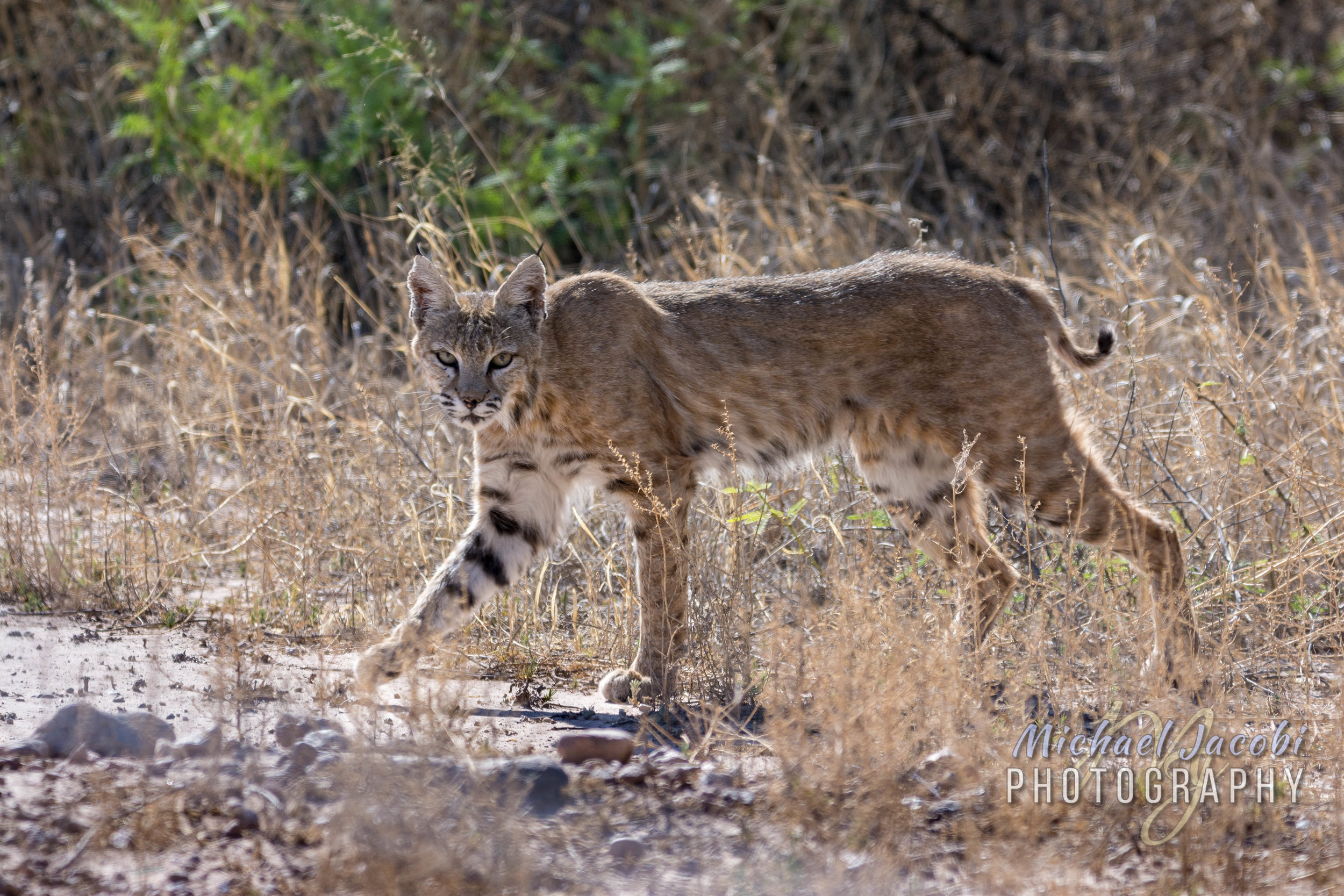
Bobcat (Lynx rufus), Willow Tank near Arizona/New Mexico state line.

Bobcat (Lynx rufus), Willow Tank near Arizona/New Mexico state line.

Another mammal thrill was my encounter with a mountain lion near my corral campsite, but it was over in seconds and the cat's profile is just a phantom memory. The more commonly seen wild cat is the Bobcat and one day when I was about to leave Willow Tank after doing some chores there for Friends of Cave Creek Canyon, this one visited me. Willow Tank is the wildlife pond that we maintain that formerly was an agricultural holding tank for flooding cotton fields. The bobcat was in the desert scrub bushes on the other side of the road from Willow Tank's gate. I grabbed my camera and followed it as it moved parallel to the road, it's sleek shape moving in and out of sight behind the creosotebush, mesquite and other shrubs and desert trees. When I lost sight of it I would quickly move farther up the road in the direction it was heading. It continued parallel to the road, perhaps thirty or forty yards into the scrub. To my surprise, it angled closer to the road and turned towards me. I watched it, photographed it, and marveled at how casual its gait was. It watched me, but seemed indifferent to my presence. I walked toward it as it crossed the road and went underneath my truck. I thought I might have to try to scare it away to leave, but it soon continued its slow stroll into Willow Tank itself where I hope it found a meal of one of the many desert cottontail rabbits currently occupying the temporarily drained pond. It looked a little weary and emaciated.

bobcat_2.jpg

#92 - Chiri Charm - Portal/Rodeo

Last year I visited many breathtaking places across the U.S. In Florida, in January and again in March after a February Malaysia/Borneo odyssey, from the Keys to Kissimmee Prairie. On to Texas in April, from Sea Rim State Park on the Gulf, clinging to the Mexican border west to Laredo's urban Lake Casa Blanca International State Park, on to wondrous Big Bend National Park and then Seminole Canyon Historical Site. Then April saw me jumping back and forth between New Mexico to Arizona, camped at places like Picacho Peak State Park between Tucson and Phoenix, visiting the Superstition Mountains and the Sky Island complexes of the Santa Catalina and Santa Rita Mountains.

Last weekend, while I was in Paradise banding hummingbirds, the annual Elegant Trogon count took place here in the Chiricahuas. As arriving birders associated with the Tucson Audobon Society arrived, I was struck by the newcomers who had never visited the Chiris before and their love-at-first-sight enthusiasm for Cave Creek Canyon. Their home was Madera Canyon, another American nesting spot of the Mexican bird. Situated in the Santa Ritas south of Tucson, about halfway between that population center and the Mexican border, Madera Canyon is incredible. I visited it first with my arachnologist friend Brent and his students, and then again after they moved on toward California. I look forward to my next visit. But it is a short drive from the Sonoran desert sprawl of America's thirty-third largest city, whose greater metropolitan area is home to more than one million people. It ain't exactly a "well kept secret" as I have heard remarked about Cave Creek Canyon.

Even closer to Tucson city limits, the Santa Catalinas draw daily visitors from Phoenix as well. The Catalina Highway that rises to above 9000 feet near Mt. Lemmon is thirty miles of perfectly paved access to high elevation heat relief. I look forward to my next visit to this Sky Island as well, and have fond memories of a hot and dry day in Tucson becoming an evening flipping snow-covered rocks in successful search of scorpions.

The Trogon count participants that spend a great deal of time in Madera Canyon marveled at the Chiricahuas just as I did when I visited last year for a week that turned into four months. I still marvel every day, and each day I work at the VIC someone remarks on the uniqueness and splendor of Arizona's largest Sky Island. Far off the beaten path, the Chiri charm and cheer takes a little more work to experience.

Some Arizonans who venture toward the Chiris simply visit the Chiricahua National Monument on the west side of the range after leaving the interstate at Willcox. Fort Bowie National Historic Site lies in the valley below and a full day's outing can be had visiting both. Only the few cross Onion Saddle to descend toward Cave Creek Canyon and Portal. Others make Cave Creek Canyon their destination, most staying on the interstate into New Mexico and dropping south on Highway 80 five miles into the state and proceeding thirty miles to Rodeo, NM before heading back west into Arizona to Portal.

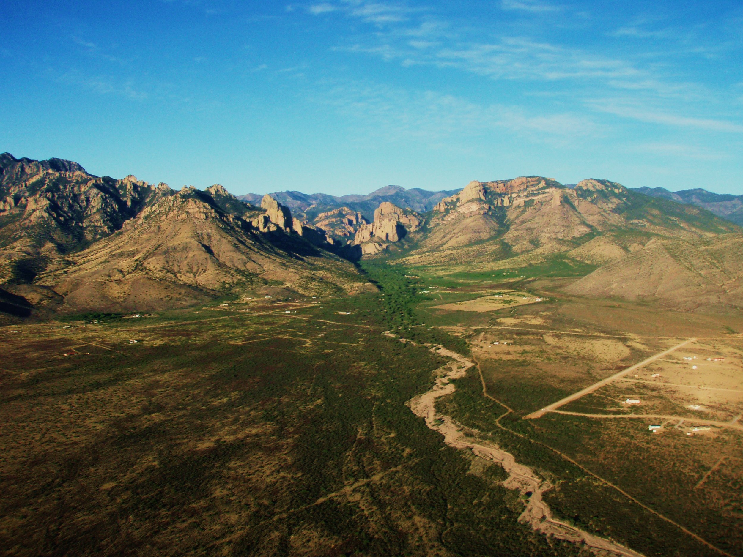
Aerial view of Portal, AZ and Cave Creek Canyon. Photo by BAlvarius/Wikimedia Commons

Aerial view of Portal, AZ and Cave Creek Canyon. Photo by BAlvarius/Wikimedia Commons

Straddling two states, the Portal/Rodeo community has a charm that affects arrivers who don't mind being in the middle of nowhere. But first, the confusing time zones takes getting used to. It isn't just that it is one hour earlier in Arizona and you may enter and leave both states multiple times in a day. It's that today we are slaves to smartphones and, when you leave the WiFi offered by the VIC or your lodging or wherever, your cell phone will pick up signal from New Mexico only. You may have remained in Arizona, but now your phone makes you think you've lost an hour. I've changed my setting to disable automatic time zones. The bigger issue with the New Mexico cell signal is in the event of an emergency. Should you need to call 911 you will be contacting services in New Mexico and may have to request transfer to Cochise County ARIZONA emergency dispatch. I have the direct numbers in my phone. Verizon is the only reliable carrier for use in the area, but the signal may be weak or nonexistent in some spots. One of the many services the Friends of Cave Creek Canyon provides at the VIC is public WiFi during open hours (9-4 daily, AZ time) and a Verizon Hotspot.

The VIC - Cave Creek Canyon Visitor Information Center

The VIC - Cave Creek Canyon Visitor Information Center

Nine miles into Arizona, Portal is the hub of the area. Although Rodeo, New Mexico has a post office and a small diner that has an extremely limited selection of groceries, arguably the only two major establishments are Rusty's RV Ranch and the Chiricahua Desert Museum. The latter is the must see attraction in the area. It sits between Rusty's to the north and the Rodeo proper to the south, directly where Highway 533 heads towards Portal and Cave Creek Canyon. After passing State Line Road you are in Arizona and Hwy. 533 is better known as Portal Road. 

Chiricahua Desert Museum & Geronimo Event Center - Image from CDM Facebook

Chiricahua Desert Museum & Geronimo Event Center - Image from CDM Facebook

The Sky Island Grill & Grocery will soon become the third Rodeo establishment of note, but it is only just now sometimes opening its doors after being in development for years. It sits just inside New Mexico a short distance from the Chiricahua Desert Museum just before the bend to the northwest takes you into Arizona.

Consisting really of only one intersection, the crossroads of which is a complex known Portal Peak Lodge and Portal Store & Cafe, the tiny eclectic community of Portal, said to be home to more Ph.Ds per capita (retired) than anywhere else in Arizona, is centered on this venue for lodging, good food and, occasionally, live music. Up the hill to the north is the Portal Rescue & Fire where special events and meetings are also held and south down Rock House Road is the small post office and library. The rest of Portal are the residences that stretch out into the desert or up toward the canyon. I overheard one resident in the library mentioning how she feels like there are two communities - the desert and the canyon. This is where two worlds meet; the Chihuahuan Desert of Rodeo and eastern Portal and the foothills and entrance to Cave Creek Canyon, the Coronado National Forest and the Chiricahua Mountains.

Storefront - Lodge behind left - Image from web search

Storefront - Lodge behind left - Image from web search

You may now be wondering about how many people live in the hamlet of Portal. A web search results in wide-ranging population estimates from 100 to more than 1300. Homes are secluded down dirt roads branching from Portal Road, but I can't imagine where one thousand or more people would reside. There aren't exactly apartment complexes. It is no surprise that the median age is just above my own soon-to-be 54, or that most households consist of just two people, generally a retired couple. It also isn't a surprise that more than 10% hold a graduate degree. What Portal residents have most in common is that many are birders and/or hikers and/or astronomers. And they live in one of the most beautiful places in America. They are also more than a little adventurous and industrious, and choose to live somewhere fairly remote. It is twenty-five miles each way to Animas, NM, where the Valley Mercantile offers hardware, feed, convenience groceries and, thankfully via 24-hour pumps, the closest fuel. About the same distance up a primitive mountain road and almost one hour's drive takes you to the interstate and San Simon, AZ where you can also buy fuel and one gas station offers a pretty good selection of produce, groceries and hardware. Most drive 75 miles northwest, entering New Mexico before returning to Arizona, to the Safeway in Willcox, AZ, or instead travel 60 miles or so southeast to the Wal-Mart in the border town of Douglas, AZ in order to shop. These cities also offer the closest health care services and other needs. Northeast of Portal-Rodeo, Lordsburg, NM is about the same distance as Douglas, but its little grocery store is pretty dismal. Some plan weekend trips 350 miles round-trip to Tucson to take care of many tasks every few months. It's the price you pay to dwell next door to a canyon and mountain range where Elegant Trogons and Blue-throated Hummingbirds fly, without the influx of city folk seen by Madera Canyon and other wonderful places.

Blue-throated Hummingbird, Cave Creek Canyon

Blue-throated Hummingbird, Cave Creek Canyon

Those, like me, who visit the Portal-Rodeo area and the northeast side of the Chiricahuas have a handful of choices for lodging. Here in Cave Creek Canyon, there are three forest service campgrounds and, beyond where the paved road ends and becomes a primitive road climbing the mountain, there are some excellent dispersed campsites. Those seeking cooler climes may wish to camp at Barfoot or Rustler Park, where the 8000 foot-plus elevation provides respite from the heat. However, like the other dispersed sites, there are no toilets. Those with RVs best stay at Rusty's; only one of the three USFS campsites can accommodate small campers and there are no hook-ups. Many birders choose one of several B&Bs along Portal Road or Portal Peak Lodge. The USFS also has two rental cabins on each side of the VIC. Housekeeping cottages at Cave Creek Ranch are one of the more popular places for birders to stay and it is within walking distance of the VIC. In fact, owner Reed Peters is also the president of Friends of Cave Creek Canyon, and it is at his Ranch that I receive mail, packages and do my laundry. Guests at Cave Creek Ranch enjoy coatis, javelinas, a large population of very tame Coues or Desert White-tailed Deer and a spectacular variety of birds.

One of the variety of cottages at Cave Creek Ranch - Image from CCR website

One of the variety of cottages at Cave Creek Ranch - Image from CCR website